Note
Go to the end to download the full example code.
1.3b: 2-D sections
Importing
import gempy as gp
import gempy_viewer as gpv
import numpy as np

np.random.seed(1234)
Setup the model
Importing the data from CSV-files and setting extent and resolution
data_path = 'https://raw.githubusercontent.com/cgre-aachen/gempy_data/master/'

geo_model: gp.data.GeoModel = gp.create_geomodel(
    project_name='Tutorial_ch1_1_Basics',
    extent=[0, 2000, 0, 2000, 0, 750],
    resolution=[20, 20, 20],  # * Here we define the resolution of the voxels
    refinement=4,  # * Here we define the number of octree levels. If octree levels are defined, the resolution is ignored.
    importer_helper=gp.data.ImporterHelper(
        path_to_orientations=data_path + "/data/input_data/getting_started/simple_fault_model_orientations.csv",
        path_to_surface_points=data_path + "/data/input_data/getting_started/simple_fault_model_points.csv",
        hash_surface_points="4cdd54cd510cf345a583610585f2206a2936a05faaae05595b61febfc0191563",
        hash_orientations="7ba1de060fc8df668d411d0207a326bc94a6cdca9f5fe2ed511fd4db6b3f3526"
    )
)

gp.map_stack_to_surfaces(
    gempy_model=geo_model,
    mapping_object=  # TODO: This mapping I do not like it too much. We should be able to do it passing the data objects directly
    {
        "Fault_Series": 'Main_Fault',
        "Strat_Series": ('Sandstone_2', 'Siltstone', 'Shale', 'Sandstone_1')
    }
)

gp.set_is_fault(
    frame=geo_model.structural_frame,
    fault_groups=['Fault_Series']
)
Surface points hash:  4cdd54cd510cf345a583610585f2206a2936a05faaae05595b61febfc0191563
Orientations hash:  7ba1de060fc8df668d411d0207a326bc94a6cdca9f5fe2ed511fd4db6b3f3526
Add sections
pass section dictionary with startpoint, endpoint and resolution for every section:
gp.set_section_grid(
    grid=geo_model.grid,
    section_dict={
        'section1': ([0, 0], [2000, 2000], [100, 80]),
        'section2': ([800, 0], [800, 2000], [150, 100]),
        'section3': ([0, 200], [1500, 500], [200, 150])
    }  # p1,p2,resolution
)
Active grids: GridTypes.DENSE|SECTIONS|NONE
Add topography
gp.set_topography_from_random(
    grid=geo_model.grid,
    fractal_dimension=1.2,
    d_z=np.array([300, 750]),
    topography_resolution=np.array([50, 50])
)
Active grids: GridTypes.DENSE|TOPOGRAPHY|SECTIONS|NONE

Topography(_regular_grid=RegularGrid(resolution=array([20, 20, 20]), extent=array([   0., 2000.,    0., 2000.,    0.,  750.]), values=array([[  50.  ,   50.  ,   18.75],
       [  50.  ,   50.  ,   56.25],
       [  50.  ,   50.  ,   93.75],
       ...,
       [1950.  , 1950.  ,  656.25],
       [1950.  , 1950.  ,  693.75],
       [1950.  , 1950.  ,  731.25]], shape=(8000, 3)), mask_topo=array([], shape=(0, 3), dtype=bool), _transform=None, _base_resolution=array([2, 2, 2])), values_2d=array([[[   0.        ,    0.        ,  525.81364595],
        [   0.        ,   40.81632653,  534.4311714 ],
        [   0.        ,   81.63265306,  545.21138351],
        ...,
        [   0.        , 1918.36734694,  493.45417828],
        [   0.        , 1959.18367347,  505.51902125],
        [   0.        , 2000.        ,  516.62320964]],

       [[  40.81632653,    0.        ,  520.02419799],
        [  40.81632653,   40.81632653,  529.19849936],
        [  40.81632653,   81.63265306,  540.73889549],
        ...,
        [  40.81632653, 1918.36734694,  485.70563878],
        [  40.81632653, 1959.18367347,  498.13591443],
        [  40.81632653, 2000.        ,  509.94870633]],

       [[  81.63265306,    0.        ,  512.29034438],
        [  81.63265306,   40.81632653,  522.38242549],
        [  81.63265306,   81.63265306,  533.74749759],
        ...,
        [  81.63265306, 1918.36734694,  475.96047534],
        [  81.63265306, 1959.18367347,  488.33556325],
        [  81.63265306, 2000.        ,  500.75092545]],

       ...,

       [[1918.36734694,    0.        ,  536.8572301 ],
        [1918.36734694,   40.81632653,  549.32197157],
        [1918.36734694,   81.63265306,  561.72341993],
        ...,
        [1918.36734694, 1918.36734694,  503.24054915],
        [1918.36734694, 1959.18367347,  513.73925164],
        [1918.36734694, 2000.        ,  525.47837607]],

       [[1959.18367347,    0.        ,  534.68908826],
        [1959.18367347,   40.81632653,  545.65518713],
        [1959.18367347,   81.63265306,  558.27313536],
        ...,
        [1959.18367347, 1918.36734694,  501.0502999 ],
        [1959.18367347, 1959.18367347,  512.95973605],
        [1959.18367347, 2000.        ,  524.20361683]],

       [[2000.        ,    0.        ,  530.78028142],
        [2000.        ,   40.81632653,  540.15206274],
        [2000.        ,   81.63265306,  551.79148373],
        ...,
        [2000.        , 1918.36734694,  498.47649577],
        [2000.        , 1959.18367347,  510.05476038],
        [2000.        , 2000.        ,  521.16890329]]], shape=(50, 50, 3)), source=None, values=array([[   0.        ,    0.        ,  525.81364595],
       [   0.        ,   40.81632653,  534.4311714 ],
       [   0.        ,   81.63265306,  545.21138351],
       ...,
       [2000.        , 1918.36734694,  498.47649577],
       [2000.        , 1959.18367347,  510.05476038],
       [2000.        , 2000.        ,  521.16890329]], shape=(2500, 3)), resolution=(50, 50), raster_shape=())
Active grids:
geo_model.grid.active_grids
<GridTypes.DENSE|TOPOGRAPHY|SECTIONS|NONE: 1050>
gpv.plot_section_traces(geo_model)
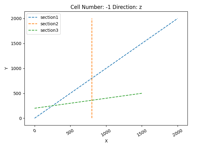
<function plot_section_traces at 0x7f582f2ef8a0>
geo_model.interpolation_options.mesh_extraction = False
sol = gp.compute_model(geo_model)
Setting Backend To: AvailableBackends.PYTORCH
GPU requested but unavailable; falling back to CPU (GEMPY_GPU_FALLBACK=True)
Setting Backend To: AvailableBackends.PYTORCH
Chunking done: 8 chunks
gpv.plot_2d(geo_model, section_names=['topography'])
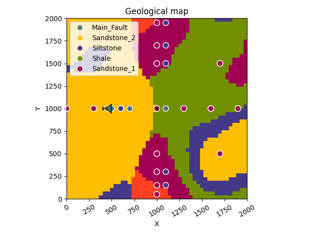
/opt/buildAgent/work/3a8738c25f60c3c9/venv/lib/python3.14/site-packages/gempy_viewer/API/_plot_2d_sections_api.py:112: UserWarning: Section contacts not implemented yet. We need to pass scalar field for the sections grid
  warnings.warn(

<gempy_viewer.modules.plot_2d.visualization_2d.Plot2D object at 0x7f5820cff3d0>
gpv.plot_2d(geo_model, section_names=['section1'])
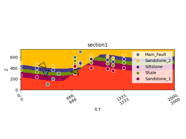
/opt/buildAgent/work/3a8738c25f60c3c9/venv/lib/python3.14/site-packages/gempy_viewer/API/_plot_2d_sections_api.py:112: UserWarning: Section contacts not implemented yet. We need to pass scalar field for the sections grid
  warnings.warn(

<gempy_viewer.modules.plot_2d.visualization_2d.Plot2D object at 0x7f5820c4b450>
gpv.plot_2d(
    model=geo_model,
    section_names=['section1', 'section2', 'section3', 'topography'],
    show_topography=True
)


# sphinx_gallery_thumbnail_number = 4
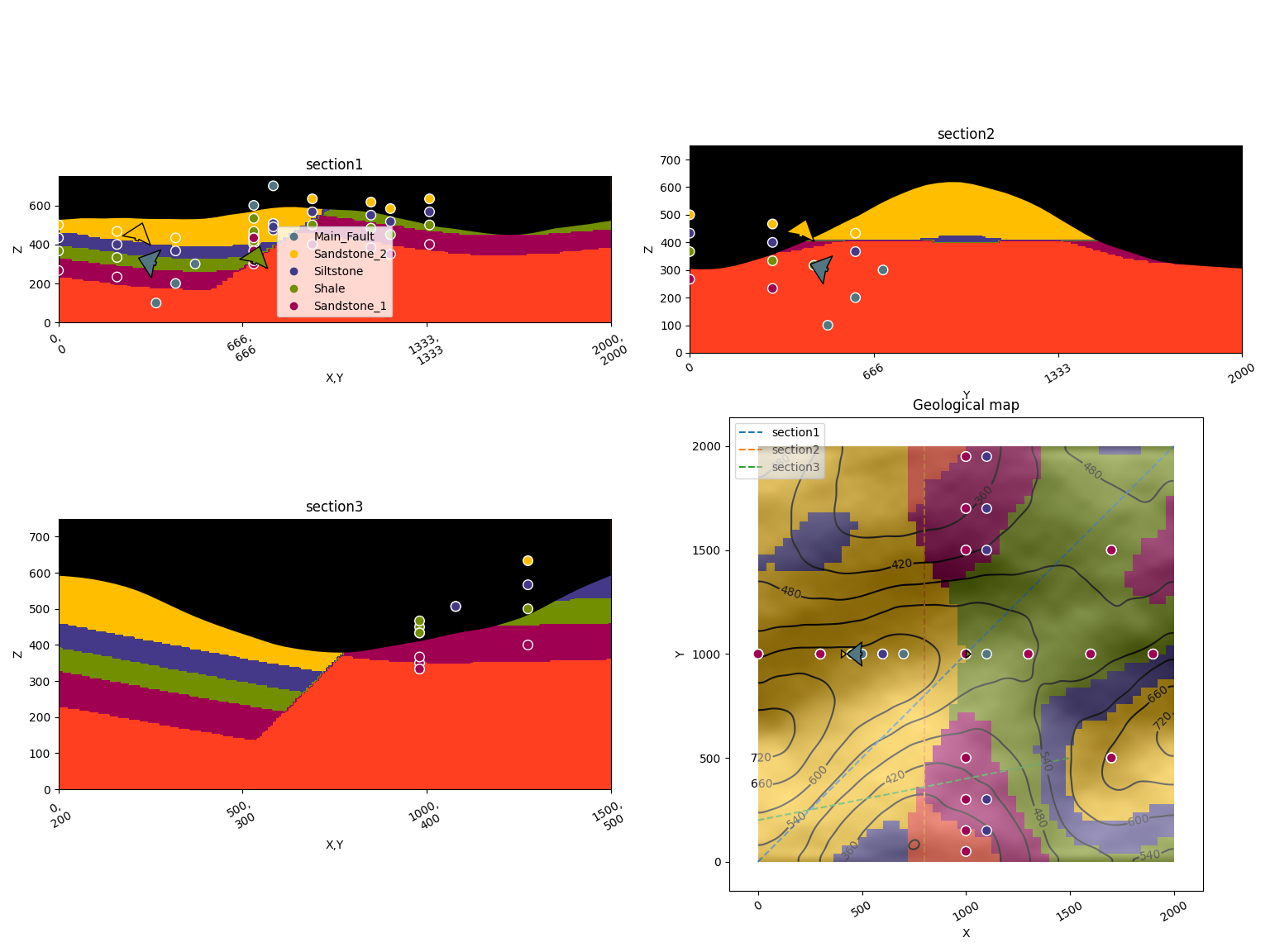
/opt/buildAgent/work/3a8738c25f60c3c9/venv/lib/python3.14/site-packages/gempy_viewer/API/_plot_2d_sections_api.py:112: UserWarning: Section contacts not implemented yet. We need to pass scalar field for the sections grid
  warnings.warn(

<gempy_viewer.modules.plot_2d.visualization_2d.Plot2D object at 0x7f580ed83e50>
Total running time of the script: (0 minutes 3.310 seconds)
