.. role:: raw-html-m2r(raw)
:format: html
Additional projects
===================
Besides the main functionality, ``GemPy`` is the basis for additional projects:
:raw-html-m2r:``
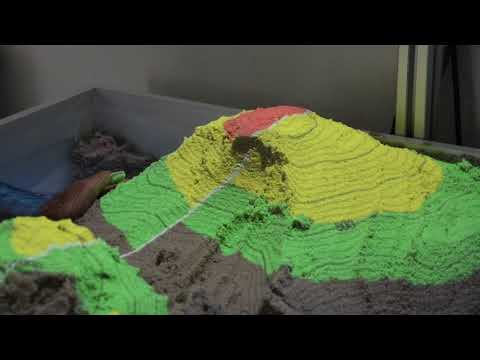
Augmented-Reality Geology Sandbox
~~~~~~~~~~~~~~~~~~~~~~~~~~~~~~~~~
New developments in the field of augmented reality, i.e. the
superimposition of real and digital objects, offer interesting and diverse
possibilities that have hardly been exploited to date.
The aim of the project is therefore the development and realization of
an augmented reality sandbox for interaction with geoscientific data and models.
In this project, methods are to be developed to project geoscientific
data (such as the outcrop of a geological layer surface or geophysical
measurement data) onto real surfaces.
The AR Sandbox is based on a container filled with sand, the surface of
which can be shaped as required. The topography of the sand surface is
continuously scanned by a 3D sensor and a camera. In the computer the
scanned surface is now blended with a digital geological 3D model
(or other data) in real time and an image is calculated, which is
projected onto the sand surface by means of a projector. This results
in an interactive model with which the user can interact in an
intuitive way and which visualizes and comprehend complex
three-dimensional facts in an accessible way.
In addition to applications in teaching and research, this development
offers great potential as an interactive exhibit with high outreach
for the geosciences thanks to its intuitive opeÍÍration.
The finished sandbox can be used in numerous lectures and public events,
but is mainly used as an interface to ``GemPy`` software and for rapid
prototyping of implicit geological models.
.. raw:: html
:raw-html-m2r:``
Remote Geomod: From GoogleEarth to 3-D Geology
~~~~~~~~~~~~~~~~~~~~~~~~~~~~~~~~~~~~~~~~~~~~~~
We support this effort here with a full 3-D geomodeling exercise
on the basis of the excellent possibilities offered by open global data sets, implemented in
GoogleEarth, and dedicated geoscientific open-source software and motivate the use of 3-D
geomodeling to address specific geological questions. Initial steps include the selection of
relevant geological surfaces in GoogleEarth and the analysis of determined orientation values
for a selected region This information is subsequently used
to construct a full 3-D geological model with a state-of-the-art interpolation algorithm. Fi-
nally, the generated model is intersected with a digital elevation model to obtain a geological
map, which can then be reimported into GoogleEarth.
.. raw:: html

:raw-html-m2r:``